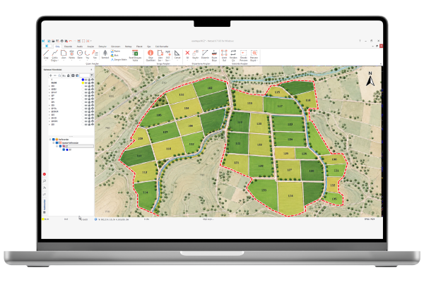
Nettop is a Netcad solution designed to support the reorganization of fragmented agricultural lands in land consolidation projects, offering comprehensive tools ranging from project preparation to the generation of registration data. It enables project processes to be conducted in an integrated environment by managing cadastral, title deed, and block information in conjunction with graphical data. Nettop generates index maps based on soil, location, and settlement scores and supports value-based subdivision operations by calculating value figures for parcels and blocks. It allows for manual or automated allocation based on landowner preferences, interview results, adjacency requests, and data regarding fixed structures. While facilitating allocation via a drag-and-drop interface, it enables the monitoring of block occupancy and remaining allocation balances. The creation, merging, subdivision, and numbering of new parcels can all be managed within the same project. Nettop imports title deed data in XLS, MDB, and XML formats into the project and supports the tracking of updated records as well as the export of editor data to Excel. Customizable editors, along with options for batch data entry, filtering, and sorting, simplify the editing and review of project data. It helps identify potential inconsistencies through checks on ownership shares, cadastral data, indices, and preferences. The origin and destination of parcels can be queried and reported directly on the graphical display. By generating institutional-standard reports, project summaries, technical dossiers, and registration data, it streamlines the review and submission processes for land consolidation projects.
Thank you, we have received your form. We will get back to you as soon as possible.
There are incorrect fields, please check and resubmit.
Reports Compliant with the DSI Technical Specification
Reports compliant with the DSI Technical Specification for Land Consolidation and On-Farm Development Services can be generated. In the generated reports, heirs are displayed in different colors, and share information and Turkish ID Number (TCKNO) details of heirs and property owners are shown.
New Allocation Screens
In the renewed Allocation Editor, the remaining value indices of parcels and the remaining value indices of blocks can be colored according to user-defined settings. In this way, block occupancy rates can be easily monitored.
Land Registry Record Filtering & Updating
A "Textual Data Transfer" window has been designed to enable land registry records to be imported and updated. Through the Textual Data Transfer window, land registry records can be viewed and filtered before the textual land registry data is loaded into the project, and the records matching these filters can be imported into the project. Before the land registry data is imported into the project, it can be reported in Excel format.
Project Control from a Single Screen
With the Project Control menu, checks can be performed from a single screen at different stages of the project. As a result of these checks, parcels that meet or do not meet the specified criteria can be reported, viewed on the graphical screen, and their attribute information can be edited.
VIDEOS
Nettop Videos
Check out the informative promotional videos about the product's features.
Nettop Registration Data
Reading Title Deed Records
Index Check
Project Controls
Automatic Distribution
F.A.Q.
Frequently Asked Questions About Nettop
Can we transfer textual land registry data?
Textual land registry data in .xml, .mdb, and .xls formats can be transferred to the project in bulk, and changed records can be tracked during land registry updates. Data entries for land registry information can be performed in bulk, and share checks can be carried out automatically.
Can we create index maps in land consolidation projects?
Index maps, which are mandatory in land consolidation projects and require considerable time to prepare, can be generated with NETTOP in a single operation, and the index areas are calculated. Through index calculations, the value of the cadastral parcel and the value of block areas are calculated, enabling entitlement calculations.
Can we design block plans?
Block plans can be designed, and block index value update reports can be generated. Block records can be created with the help of graphical and attribute editors. Labeling and subdivision operations can be carried out on block parcels.
Can we prepare Land Consolidation reports?
All Excel reports compliant with DSI standards can be generated. Project control results related to the land consolidation project, including AT1, AT2, AT7, AT8, and other reports, can be generated so that all cadastral, block, and allocation information can be checked.
Are there automated tools for allocation?
During allocation or at any desired time, queries such as where a block originated from or where a share was allocated can be performed. Manual, automatic, and graphical allocation based on parcel value indices can be carried out, shared allocation of cadastral parcels can be performed, automatic allocation by block can be carried out, and automatic allocation based on preferences can be performed.
Contact
Easily contact our sales representatives or technical support team