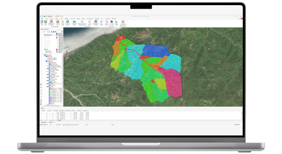
NetHydro is a hydrological analysis solution designed to model catchment areas (basins) and their associated drainage networks. It performs rainfall analyses across all distribution types, calculates peak discharges using unit hydrographs, estimates flood discharges for different return periods, and identifies flood-risk areas along flow paths.
Hydrological analyses often involve numerous steps, critical technical details, and complex controls. NetHydro simplifies this process by enabling you to perform advanced analyses with a single click, while still allowing you to review and validate results at any stage. Its intuitive interface makes it a highly user-friendly solution.
With NetHydro, you can efficiently carry out a wide range of engineering tasks, including basin modeling, calculation of surface runoff and flood discharges, floodplain analysis, identification of drainage structures, and automatic dimensioning.
The solution is widely applicable across multiple sectors and project types. It can be used in land consolidation projects to calculate the drainage of surface waters, in transportation projects such as highways and railways to plan surface water removal, in flood management projects to determine the type and size of channel structures, in dam and reservoir assessments for conducting essential hydrological studies, and in urban and regional planning processes to perform floodplain analyses. By combining ease of use with powerful analytical capabilities, NetHydro delivers practical solutions that support effective planning, design, and risk management across diverse engineering disciplines.
Thank you, we have received your form. We will get back to you as soon as possible.
There are incorrect fields, please check and resubmit.
Model all the basins in your project area with a single button. Model the basins of all the flow network that cross a route.
Multiple Basin Modeling
Model the basins of all flow network that cross a route.
Flood Flow Calculation
Automatically calculate your flood flow rates according to 5 different methods. Determine your precipitation analysis and optimal distributions.
Determining the Flood Spread Area
You just determine the criteria, then we will find your flood spread areas for you.
Automatic Locating
Let us automatically locate the places where the structures should be, the Culverts, Stilling basins, intercepting and heel ditches.
Auto Sizing
Let us automatically size your various drainage systems, especially culvert, flood protection, with all their analyses together.
Road Pipeline Drainage
You can realize the drainage of pipelines belonging to your road projects.
VIDEOS
NetHydro Promotional Videos
Check out the informative promotional videos about the product.
Symposiums
Success Stories
F.A.Q.
Frequently Asked Questions About NetHydro
Can rainfall analyses be performed for all distribution types?
Yes. NetHydro provides access to the location and at least 15 years of measurement data from all rainfall stations established by the Turkish State Meteorological Service. It automatically performs rainfall analyses using the Smirnov–Kolmogorov test and recommends the most suitable distribution type to be used in flood discharge calculations.
Can flood discharge calculations be made for different return periods?
Yes. NetHydro automatically performs unit hydrograph peak discharge calculations using the Mockus, Snyder, Rational, Synthetic, and DSI Synthetic methods. The calculated unit hydrograph peak discharge is multiplied by the flow value obtained from rainfall analyses, and flood discharge values for different return periods are automatically generated.
Can flood analyses identify flood-prone areas?
Yes. Based on the calculated flood discharge, NetHydro automatically determines the flood boundaries for a selected return period along the analyzed flow path. Flood boundaries at each cross-section can be dynamically tracked using the HEC-RAS cross-section viewer.
What data are required to model catchments and drainage networks?
A digital terrain model (DTM) is all that is needed. With a single process, NetHydro can model main basins, sub-basins, and the drainage networks that define them.
Can data generated from catchment analysis be used within a GIS structure?
Yes. Catchments and flow paths are created in a GIS structure, and flood discharge inputs are automatically calculated. All parameters required for flood discharge calculations are computed automatically for the main basins, basins, sub-basins, and associated flow paths, and then written into the corresponding columns in the database.
Contact
Easily contact our sales representatives or technical support team