
EN
GIS (Geographic Information Systems) is a powerful technology that collects, analyzes, and visualizes every point on the Earth's surface, every event, and the relationships between them. By working with maps and geographic data, GIS supports decision making processes in a wide range of fields from urban planning to natural disaster management. GIS transforms complex geographic data into meaningful insights, enabling better analysis and more accurate decisions.
GIS is the abbreviation for “Geographic Information Systems.”
When examining the history of GIS, its roots can be traced back to ancient times. However, the emergence of modern GIS as we know it today became possible in the mid 20th century, with advancements in computer technology.

Today, GIS is a fundamental technology used in every field that requires the use of spatial data.
A GIS (Geographic Information System) operates by collecting, storing, analyzing, and visualizing spatial data. At its core, a GIS consists of the following key components:
GIS collects data from various sources such as maps, satellite imagery, sensors, and surveys etc. and organizes this data within a database, and defines spatial relationships. The collected data is linked to geographic coordinates and other attributes. Then, it is analyzed to identify spatial patterns, make predictions, and generate scenarios. Finally, the analyzed data is presented through maps, graphs, or other visual tools, making it easier to understand and enabling more informed decision making.
The core working principle of GIS is the storage of geographic data in layers. Each layer contains specific thematic information (e.g., roads, buildings, population density). These layers can be overlaid on one another, enabling complex geographic analyses to be performed.
The components of Geographic Information Systems (GIS) encompass the collection, processing, storage, analysis, and visualization of data.
The main components of GIS are:
At the core of GIS are the data collected from various sources such as maps, satellite imagery, and sensor data. This data falls into two main categories: Spatial data (location based) and attribute data (descriptive or thematic information)
This is the structure where data is systematically stored, accessed, and updated. It ensures that information is maintained accurately and securely.
GIS software performs essential functions such as data analysis, map creation, and visualization. It enables users to interpret and present geographic information effectively.
The physical infrastructure required for GIS includes computers, servers, storage devices, and data collection tools. Hardware is crucial for data processing and storage.
Professionals who use and develop GIS such as geographers, GIS specialists, engineers, analysts, and software developers are one of the system’s most vital components. Their expertise ensures the successful implementation and management of GIS.
All of these components work together at every stage from data collection to analysis to transform spatial data into meaningful information.
GIS processes and analyzes spatial information using two main types of data: spatial data and attribute data. These data types enable GIS to operate efficiently and support analysis across a variety of sectors. The commonly used data types in GIS include:
Vector data consists of geometric shapes that mathematically represent real world objects. These shapes points, lines, and polygons are frequently used in maps and geographic analyses.
Additionally, vector data includes not only location information but also the spatial attributes of each geographic feature.

Raster data is organized in numerical grids and is ideal for representing continuously varying surfaces. It is commonly used in satellite imagery, aerial photographs, and digital elevation models (DEMs). For example, a satellite image contains pixel based information about vegetation, land use, or temperature in a given area. Digital elevation models display elevation values of a terrain and are used to analyze topographic features such as slope and aspect.

A significant portion of the data used in GIS is stored in tables and databases that hold the attributes of geographic features. These tables are linked to point, line, or polygon data, providing detailed information about geographic objects.
Geographic coordinates are latitude and longitude values used to determine the exact location of a place on Earth. In GIS, geographic coordinates are used to define the positions of point data.
In conclusion, vector and raster data used in GIS form the fundamental building blocks of geographic analysis. Choosing and using these data types accurately is crucial for obtaining reliable and precise results.
Creating a GIS database enables the centralized management and analysis of geographic information in a digital environment. This maximizes the potential of spatial data, allowing for more accurate and effective decision making.GIS databases offer simple solutions to complex geographic problems. For example, they can be used to identify the best school zones in a city or to improve the productivity of an agricultural area.
Geographic Information System collects, stores, analyzes, and visualizes geographic data.
A spatial query is a method used within Geographic Information Systems to obtain quantitative and descriptive information about a specific location, area, or object.
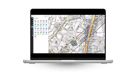
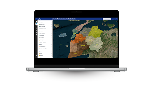
GIS maps are visual summaries of geographic data. These maps are generated by processing and analyzing raw data collected from various sources such as satellite imagery, GPS data, and sensor measurements. For example, a map showing traffic density in a city can be created by processing data from GPS devices and traffic sensors. Such a map can assist urban planners in designing new roads or public transportation routes to alleviate congestion. Additionally, when integrated with technologies like artificial intelligence and machine learning, these maps can also be used to predict future traffic flows.
GIS is a powerful tool that helps us better understand the complex structure of our world. By utilizing geographic data, these systems enable more informed decision making in various fields such as urban planning, natural disaster management, and agriculture. For example, GIS can be used to identify areas in a city that are frequently affected by flooding or to enhance the productivity of agricultural land.

In data analysis and visualization, GIS reveals complex spatial relationships by analyzing geographic data, and presents this information through maps, charts, or other visual formats. This makes the data easier to understand and more effective for decision making.
For fast and accurate decision making, Geographic Information Systems analyze and visualize complex geographic data, enabling decision makers to make quicker, more precise, and well informed choices. This, in turn, enhances operational efficiency.
For resource efficiency, GIS identifies the location and quantity of natural resources, enabling their effective planning and utilization. By reducing waste and optimizing usage, GIS enhances resource efficiency and contributes to global sustainability.
GIS companies provide software, hardware, and service solutions for the collection, analysis, visualization, and management of geographic data. They support the spatial needs of various sectors by offering tailored solutions for different industries.
Geographic Information Systems have a wide range of applications. They are used in public services such as urban planning, transportation, natural disaster management, and environmental protection, as well as in various sectors including agriculture, forestry, logistics, and energy. In addition, GIS strengthens decision making processes through spatial analysis in services like healthcare, education, real estate management, and tourism. Across all these fields, GIS enables the efficient processing of data and delivers meaningful insights to users.
In public institutions and municipalities, GIS is used to improve service areas such as urban planning, infrastructure, and disaster management. It helps ensure efficient resource management and enables the delivery of higher quality services to citizens.
In environmental and natural resource management, GIS identifies the locations of resources, supports planning for sustainable use, and monitors environmental impacts.
GIS is used in transportation and infrastructure management for the planning and improvement of road networks, bridges, and other infrastructure components. It also provides effective solutions in areas such as road network design and planning, the development of public transportation systems, logistics and distribution management, and emergency response coordination.
In the energy sector, GIS plays a critical role across many areas from infrastructure and network management to investment planning and the optimization of resource usage. It enables the management of electricity transmission and distribution lines on digital maps, identification of ideal locations for renewable energy sources, analysis to reduce energy losses, and assessment of environmental impacts. GIS stands out as a strategic solution partner during the planning and operational phases of energy projects, contributing to a more sustainable operation of the sector.
GIS applications are essential tools used for the collection, analysis, visualization, and management of geographic data. These types of software allow users to work with spatial data to create maps, conduct detailed analyses, perform data queries, and enhance decision support processes.They also provide effective and efficient solutions across a wide range of fields such as infrastructure planning, environmental management, disaster response, and urban planning contributing to more productive and streamlined operations.

A Geographic Information Systems (GIS) Specialist is a professional who collects, analyzes, and maps geographic data, and develops decision support systems based on this information. In other words, they are experts who digitally model the Earth's geographic features and generate valuable, meaningful insights from this data.
Geographic Information Systems (GIS) expertise is certified through an official exam administered by the Ministry of Environment, Urbanization and Climate Change. For detailed information about the exam, please visit the ministry's website. Applicants must have a bachelor's degree and successfully complete both theoretical and practical exams. This ensures the development of officially recognized GIS experts who have proven their competence in the industry.
A GIS specialist contributes to decision making processes by ensuring the accurate and efficient use of maps and geographic data. They perform spatial analyses, manage databases, and use GIS software to develop solutions tailored to sector specific needs.In addition, they guide users to get the most out of GIS systems, create databases, and support the effective use of these systems.
GIS applications offer a wide range of use cases from analyzing urban traffic congestion and mapping natural resources to optimizing product distribution networks and tracking the spread of diseases.Additionally, GIS is effectively used in various sectors for purposes such as monitoring forest fires, managing water resources, tracking environmental pollutants, analyzing agricultural productivity, and mapping crime patterns.
Geographic Information Systems (GIS) software refers to tools used for the collection, analysis, visualization, and management of geographic data. These tools offer effective solutions in areas such as urban planning, environmental management, and disaster response, enhancing decision support processes.
GIS based projects are used across a wide range of fields and scales, including:
GIS training programs equip participants with the skills to effectively use Geographic Information Systems software for collecting, analyzing, visualizing, and managing spatial data. These courses cover both fundamental GIS knowledge and advanced analysis techniques, often aiming to develop expertise in areas such as environmental management, urban planning, and disaster management.
With over 35 years of experience, Netcad holds a leading position in the field of Geographic Information Systems in Turkey. Through its integrated CAD and GIS solutions, Netcad GIS is designed to meet a wide variety of demands from users across different sectors. Netcad GIS offers users a broad range of capabilities, including map creation, data analysis, and 3D modeling.
Constantly updated with an agile software development philosophy, Netcad provides customizable solutions tailored to the specific needs of various industries and users. This enables professionals working in fields such as engineering, planning, environment, and energy to manage their projects more quickly, accurately, and efficiently.


