Netcad 3D+ module is a powerful solution developed to visualize engineering and planning projects in a fast, effective, and realistic way in a three-dimensional environment. Fully compatible with all Netcad products, 3D+ supports your projects with rich tools for digitizing, modeling, simulation, and presentation. With the interactive 2D / 3D transfer feature, project layers are transferred to three dimensions in a single step, color and style properties are preserved, and updates made in the source project are automatically reflected without the need to create an intermediate file. With 3D grid tools, axis intervals, elevation, and coordinate labels can be easily edited, and visualization can be personalized with different colors and transparency options. With advanced 3D visualization and simulation capabilities, you can view your projects from different angles and create a realistic scene with shading, lighting, camera, fog, and atmospheric effects. You can test dynamic scenarios with vehicles, aircraft, or other models you add, and record the results as videos. In addition, the 3D+ module enables you to perform detailed analysis on your projects with advanced functions such as digitizing, measurement and inquiry, sectioning, height visualization, and satellite imagery draping. With its powerful presentation interface, you can manage multiple data layers simultaneously and present your projects to decision-makers in an impressive and persuasive way.
Thank you, we have received your form. We will get back to you as soon as possible.
There are incorrect fields, please check and resubmit.
All project layers at any scale, prepared with Netcad modules, can be transferred to 3D with a single step while preserving their color and style features. At the same time, you can automatically transfer the changes made in the source project to 3D+ without the need to create interim files again.
3D Grid
You can automatically add 3D grids to the created model, optionally set grid axis intervals, elevation and coordinate labels. You can view the changes instantly on the model. You can color your grid using different color and style features and define transparency by using transparency capability.
Stereo Viewing Options
You can obtain three-dimensional stereo images by using stereo capabilities of 3D+. You can view this screen in 3D with special glasses used to examine stereo screens. 3D+ supports many different stereo view modes.
3D Visualization and Simulation
With its navigation and visualization capabilities, the 3D module provides the ability to view the model from any desired angle and direction, in both perspective and orthogonal structure, and in different windows. You can edit your model with shading, fog, camera, sky, and light effects, and apply transitions in various background color tones. You can perform simulations with different tools and record videos.
3D Digitizing
You can digitize by using advanced point capture tools on all kinds of 3D models, edit elevations and transfer the data you produced to the 2D screen. You can lock the 3D screen at any time and digitize by using it like a 2D screen. You can enjoy digitizing in three dimensions with 3D+.
3D Measurement and Querying Tools
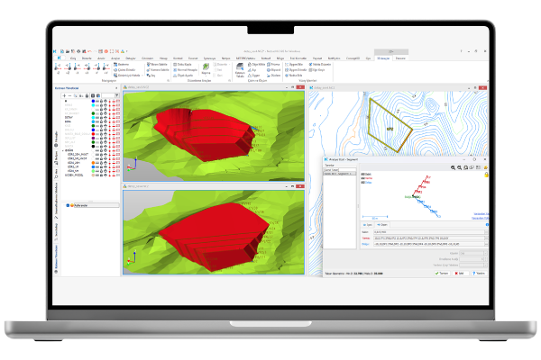
It can query 2D / 3D surface area, angle, length and object information. You can view the query results on the query screens that open interactively, and add the angle and length values as labels to the 3D screen.
3D Cross-Section Tools
With the 3D+ section tools, you can take sections from any desired direction using different plane options, use drawing, measurement, and inquiry tools on the sections, and create dynamic transitions between them. In this way, you can instantly and automatically check every project produced, from route designs to field applications, from typical sections to progress payments.
Raster Overlaying on Terrain Model
Thanks to the raster support, you can automatically overlay the raster data of the project (satellite images, aerial photographs, raster maps in different scales) on the 3D terrain model when desired.
F.A.Q.
Frequently Asked Questions about 3D+
For what purpose is Netcad 3D+ used?
Netcad 3D+ is used for three-dimensional modeling, visualization, and analysis in engineering, urban planning, infrastructure, and mapping projects. You can easily transfer your 2D data into a 3D environment, take sections, perform simulations, and prepare visual presentations.
Can I convert my 2D data to 3D?
You can transfer your 2D data to 3D in a single step. All layers are converted into a three-dimensional model while preserving their style information.
Can I perform measurements with Netcad 3D+?
Length, area, angle, and height measurements can be performed. Measurement results can also be displayed on the 3D screen.
Is there a 3D sectioning feature?
You can take sections from the project using plane or multi-plane section tools, and perform drawing and measurement on these sections.
What visualization options does Netcad 3D+ offer?
Realistic visualization can be achieved with lighting, shading, fog, sky, and camera effects. In addition, satellite images and raster maps can be overlaid onto the 3D terrain.
Contact
Easily contact our sales representatives or technical support team