Netmap is a Netcad solution that enables the preparation of zoning and land distribution cadastre projects with full compliance to regulations. It produces data integrated with TKGM’s TAKBİS standards and generates documents and reports in accordance with the Regulation on Land and Plot Arrangements and the 2024/5 Circular. Thanks to its ease of use and compliance with standards, Netmap is widely used by municipalities, public institutions, and licensed surveying and cadastre offices. Netmap supports distribution applications based on Article 18, as well as regulatory arrangements and geometry modifications under Articles 15 and 16, providing sketch and declaration outputs for these processes. Keeping up with current legislation, Netmap includes ready-to-use templates in its Documents and Reports module updated for the 2024/5 revisions, allowing easy generation of project outputs during planning stages. With the Parcel Editor, users can produce balance, consolidation, and subdivision reports with error tolerance calculations. The requirements of Article 18 of the Zoning Law No. 3194 are fully addressed through the functions of the Distribution Editor. Features such as Bulk Data Entry and On-Screen Data Capture facilitate both textual and graphical data input. Additionally, DOP (Land Readjustment Share) calculations and reports, updated in line with relevant regulations, ensure all distribution-related needs are met. In summary, Netmap provides an end-to-end solution for land distribution and zoning parcel projects—from transferring cadastral data into the application to generating official land registry outputs.
Thank you, we have received your form. We will get back to you as soon as possible.
There are incorrect fields, please check and resubmit.
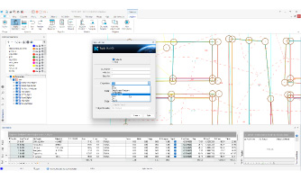
Netmap enables calculations based on error tolerance in compliance with the latest regulations. Depending on whether a parcel is classified as definitive (archive-approved) or provisional, calculations can be performed accordingly. Balancing operations and area outputs are generated based on error ranges and internal/external tolerance conditions.
Regulation-Compliant Documents and Reports
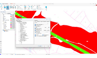
Project outputs can be easily prepared with document and report templates fully aligned with TKGM’s latest regulations. The application includes ready-to-use templates such as Creation Sketches, Subdivision Declarations, Application Sketches, and many more. By keeping up with legislative updates, the Documents and Reports option meets all industry needs. Users can prepare Survey Sketches, Declarations, and custom reports through both manual and automated methods.
Automated Data Entry & Editing Functions
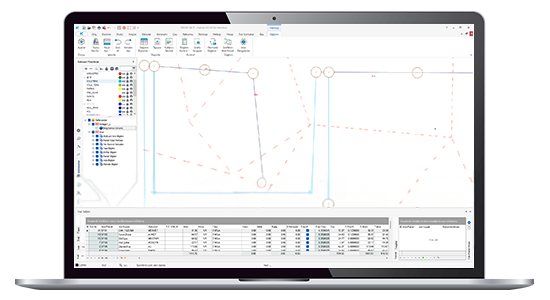
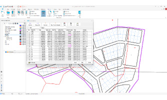
Cadastral and zoning parcel data can be entered into the project in bulk, and graphical screen information can be automatically transferred into the project. After distribution operations are completed in NETMAP, actions can be undone or redone as needed. Completed records can be reversed—zoning ownerships can be converted back to cadastral ownerships. Records can also be updated or deleted in bulk, based on parameters such as block, parcel number, owner.
Graphically Interactive Smart Interfaces
These interfaces provide dynamic, automated, and intelligent functions for project control and management at every stage. They establish spatial relationships between cadastral and zoning parcels, calculate the proportion of distributed shares relative to their parcel boundaries, and generate reports for zoning parcels that have not been distributed. These reports can be displayed dynamically in thematic structures, fully integrated with graphical interaction.
VIDEOS
Netmap Videos
Informative videos about the new features of the product.
Fully Automatic Distribution & Graphic Distribution
Monitoring Distribution Queries Thematically With Single Click
Control Functions with Graphical Interactivity
Comparison of Old and New Title Deed Data
Automatic Data Entry & Editing Functions
Distribution to Multiple Zoning Parcels at One Time
F.A.Q.
Frequently Asked Questions about Netmap
What is Netmap and where is it used?
Netmap is a Netcad solution that supports zoning, land distribution, and parceling applications across all project stages.
What does Article 18 of the Zoning Law cover?
Article 18 of the Zoning Law regulates the redistribution of parcels by applying a Land Readjustment Share (DOP). Through this process, public areas such as roads, parks, schools, mosques, and health facilities are created, while the remaining parcels are redistributed to owners in accordance with the zoning plan.
What is the Land Readjustment Share (DOP) and how is it applied in Netmap?
As defined in Article 18 of the Zoning Law No. 3194, the Land Readjustment Share (DOP) is the portion of land deducted from parcels for public use. In Netmap, the DOP is automatically calculated during zoning applications, ensuring that land required for public services is allocated, and the remaining parcels are redistributed to landowners in an organized and planned manner.
How is heir data (inheritance entry) managed in Netmap?
In the distribution screen, under the Cadastre tab, the relevant parcel is selected. From the right-hand panel, the “Heirs” option is chosen, and by pressing the F3 key, a new row is opened to easily enter the heirs’ information into the system.
What is the Error Tolerance, and how is it used in Netmap?
In cadastral maps, the error tolerance is a legal-technical criterion defined by the new regulation, describing acceptable discrepancies in measurements and surface areas depending on the production method and scale. In Netmap, error ranges are determined based on parcel production methods and reported accordingly.
Testimonials From Netmap Users
In our department, faculty and students utilize Netcad software in their departmental courses. Applications are explained using the Netcad Main module in the Computer-Aided Map Drawing course. These studies include curve drawing and transformation applications using the Raster and NetSurf modules. Netmap module is used in projects within the Zoning Information Application course. In the Road Information and Application course, the Netpro module is used to design road projects. The NetKamu module is used in the Expropriation Technique Application course. Expropriation projects are implemented using this module. As part of the Land Consolidation Project course, consolidation projects are prepared using the Nettop module.
Assoc. Prof. Saffet Erdoğan
Afyon Kocatepe University
Contact
Easily contact our sales representatives or technical support team